
YMS: Yamashiro forest meteorology research site
General site details
| Site name | Yamashiro forest meteorology research site |
|---|---|
| AsiaFlux site code | YMS |
| Location | Yamashiro, Souraku, Kyoto, Japan |
| Position | 135º 50' 46.2" E, 34º 47' 41.2" N (World Geodetic System 1984) |
| Elevation | 225 m above sea level (World Geodetic System 1984) |
| Slope | 10 degree |
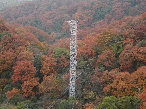
| Terrain type | Forest on complex terrain |
| Area | More than 10km2 |
| Fetch | More than 5km to north and east direction, 2km to west and 3km to south directions |
| Climate | warm temperate, Cfa |
| Mean annual air temperature | 15.5 deg |
| Mean annual precipitation | 1449 mm |
| Vegetation type | deciduous broadleaved secondary forest |
| Dominant Species (Overstory) | Quercus serrata, Ilex pedunculosa |
| Dominant Species (Understory) | Rhododendron reticulatum, Rhododendron macrosepalum |
| Canopy height | 6-20 m |
| Age | 50-60 years |
| LAI | 1.2 (winter) - 4.8(summer) |
| Soil type | immature forest soil with sandy weathered granite |
Observation
Eddy Covariance method (CO2)
| System | Open- (CO2 flux, latent heat flux) and Closed-path system (CO2 flux) |
|---|---|
| Wind speed | Three-dimensional sonic anemometer-thermometer (DA600, KAIJO, Japan) |
| Air temperature | Three-dimensional sonic anemometer-thermometer (DA600, KAIJO, Japan) |
| Water vapor | Band pass covariance(HMP-45,Visala) Open-path(Li-7500 LI-COR, USA) |
| CO2 | Closed-path (LI-6262 or LI-7000, LI-COR, USA) |
| Measurement height | 36.1 m |
| Sampling frequency | 10 Hz |
| Averaging time | 30 min |
| Data logger | DRM3a, TEAC, Japan |
| Data storage | MO |
| Original data | Raw data |
Meteorology
| Observation items | Levels/Depth | Instrument |
|---|---|---|
| Global solar radiation(incoming) | 26.4 m | Pyranometer (CM6F, Kipp & Zonen, Netherland) |
| Global solar radiation (outgoing) | 26.4 m | Pyranometer (CM6F, Kipp & Zonen, Netherland) |
| Long-wave radiation(incoming) | 26.4 m | Pyrgeometer (MS-202F,EKO,Japan) |
| Long-wave radiation(outgoing) | 26.4 m | Pyrgeometer (MS-202F,EKO,Japan) |
| Net radiation | 26.4 m | Net radiometer (CN-11, EKO, Japan) |
| PPFD (incoming) | 26.4 m | PAR sensor(LI-190SA,LI-COR,USA) |
| Air temperature | 6 heights | Temperature Probe(HMP-45A,Visala,Finland) |
| Humidity | 6 heights | Humidity Probe(HMP-45A,Visala,Finland) |
| Soil temperature | about 40 points | thermocouple |
| Soil heat flux | 4 points | Soil heat flux meter(MF-81,EKO,JAPAN) |
| Soil water content | 12 points | TTDR(HYDRA, Stivens vitel, USA) |
| Wind speed | 6 heights | 3-cups anemometer (AG750, Makino, Japan) |
| Wind direction | 26.4 m | Vane ( W200P, Vector instruments, UK) |
| Precipitation | 10m,1.5m | Rain gauge (RT-5,IKEDA instruments, JAPAN) |
| CO2 concentration | 8 heights | Closed-path CO2/H2O analyzer (LI-6262, LI-COR, USA) |
Other
| Soil respiration | Continuous |
| Photosynthesis | 2006 summer - (LI-6400,LI-COR, USA) |
| Ecological investigation | Tree heights, stand density, diameter |
Observation Period and Data Availability
| Measurement Period | November 1999 to present |
|---|---|
| Measurement Frequency | Continuous |
| Data Availability | N/A |
Contact
Yuji Kominami (kominy[at]ffpri.affrc.go.jp)
Takafumi Miyama (tmiyama[at]ffpri.affrc.go.jp)
Kansai research center Forestry and Forest Products Research Institute68 Nagaikyutaroh, Momoyama, Fushimi, Kyoto,Kyoto
612-0855, JapanTel: +81-75-611-1201, Fax: +81-75-611-1207
[Soil respiration] Koji Tamai (a123[at]ffpri.affrc.go.jp) Kyushu research centerForestry and Forest Products Research Institute4-11-16 Kurokami, Kumamoto,Kumamoto 860-0862, Japan Tel: +81-96-343-3168 Fax: +81-96-344-5054
Infrastructure
Tower, Electrical power (100V AC 60Hz)
Research Fund
Research grant #199903 (1999-2002) of the Forestry and Forest
Products Research Institute
Research grant #200303 (2003-2005) of the Forestry and Forest Products Research Institute