
TBK: Taehwa Broadleaf forest
General site details
| Site name | Taehwa Broadleaf forest |
|---|---|
| AsiaFlux site code | TBK |
| Location | Docheok-myeon, Gwangju-si, Gyeonggi-do, Republic of Korea |
| Position | 37° 18'15" N, 127° 18'50" E |
| Elevation | 251 m a.s.l |
| Slope | Dominant slopes 10~25° |
| Terrain type | Mountainous area |
| Area | 497 ha |
| Fetch | 400m × 200m |
| Climate | Temperate (snow -winter dry- hot summer) (Dwa) |
| Mean annual air temperature | 11.67 ℃ (2015) |
| Mean annual precipitation | 939.4 mm (2015) |
| Vegetation type | Mixed deciduous/coniferous forest |
| Dominant Species (Overstory) | Pinus spp. and Quercus spp. |
| Dominant Species (Understory) | Styracaceae obassia and Morus bombycis |
| Canopy height | 19.5 m |
| Age | 40 - 60 years |
| LAI | Foliage Area Index, 1 ~ 6 (±1), max in June |
| Soil type | loam |
Observation
Eddy Covariance method (CO2)
| System | Enclosed path (CO2 flux, latent heat flux) |
|---|---|
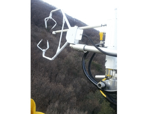
| Wind speed | 3D sonic anemometer (CSAT3) |
| Air temperature | 3D sonic anemometer (CSAT3) |
| Water vapor | Enclosed path infrared gas analyzer (LI7200) |
| CO2 | Enclosed path infrared gas analyzer (LI7200) |
| Measurement height | 27 m |
| Sampling frequency | 10 Hz |
| Averaging time | 30 min. |
| Data logger | CR3000, CSI |
| Data storage | HD |
| Original data | Raw data (and statistics) |
Meteorology
| Observation items | Levels/Depth | Instrument |
|---|---|---|
| Global solar radiation (incoming) | 27 m | Net radiometer (CNR4, Kipp & Zonen, Netherlands) |
| Global solar radiation (outgoing) | 27 m | Net radiometer (CNR4) |
| Long-wave radiation (incoming) | 27 m | Net radiometer (CNR4) |
| Long-wave radiation (outgoing) | 27 m | Net radiometer (CNR4) |
| Net radiation | 27 m | Net radiometer (CNR4) |
| PPFD (incoming) | 26 m | Quantum Sensor (LI190, Li-Cor, USA) |
| Humidity | 26 m | Humidity and Temperature Probe (HMP60) |
| Soil temperature | 0 ~ -0.1 m | Soil thermocouple probe (TCAV, CSI) |
| Soil heat flux | -0.1 m, -0.03 m | Heat flux plate (HFP01, Hukseflux Thermal Sensors B.V., Finlands) |
| Soil water content | 0 ~ -0.1m, -0.1 ~ -0.3 m, -0.3 ~ -0.6m | Water content reflectometer (CS616, CSI) |
| Wind speed | 27 m | 3D sonic anemometer (CSAT3, CSI) |
| Wind direction | 27 m | 3D sonic anemometer (CSAT3) |
| Barometric pressure | 27 m | Enclosed path infrared gas analyzer (LI7200, Li-Cor) |
| Precipitation | 21 m | Tipping Bucket (TE525, Texas Electronics, USA) |
| CO2 concentration | 27, 20, 16, 8, 5, 3, 1, 0.1 m | Profile system (AP200, CSI) |
| H2O concentration | 27, 20, 16, 8, 5, 3, 1, 0.1 m | Profile system (AP200, CSI) |
| Leaf wetness | 20, 16, 8, 0.1 m | leaf-wetness sensor (LWS-L, Decagon Devices Inc., USA) |
Other
| Photosynthesis | Portable chamber (LI6400, Li-Cor) |
| Ecological Investigation | Dendrometer band |
| Transpiration | Granier-type Sap flow measurement |
Observation Period and Data Availability
| Measurement Period | From March 2015 to present |
|---|---|
| Measurement Frequency | Continuous |
| Data Availability | N/A |
Contact
Hyun-Seok Kim (cameroncrazies[at]snu.ac.kr)
Department of Forest Sciences, Seoul National University
Bld.200/Rm.7205, Seoul National University, 1 Gwanak-ro, Gwanak-gu,
Seoul 08826, Korea
Phone: +82-2-880-4761 Fax: +82-2-365-5163
Jeonghyun Hong (august_2[at]snu.ac.kr)
Department of Agriculture, Forestry and Bioresources,
Seoul National University
Bld.200/Rm.7205, Seoul National University, 1 Gwanak-ro, Gwanak-gu,
Seoul 08826, Korea
Phone: +82-2-880-4761 Fax: +82-50-4400-2530
Infrastructure
Tower, Electrical power (AC)
Research Fund
Korea Meteorological Administration Research and Development Program
under Weather Information Service Engine (WISE) project, KMIPA-2012
-0001-2
Time series analysis of northern temperate forest characteristics and the
development of forest management for climate change adaptation project,
S111212L20110
Calibration Information
Infrared gas analyzer of EC system was calibrated approximately in every 6 months with standard CO2 gases and a dew point generator (LI610, Li-Cor). The CO2/H2O concentration profile system is being calibrated once a day for the zero(CO2, H2O) and span CO2 concentration. H2O span is being manually calibrated once a week. Other micrometeorological instruments are being calibrated approx. once in every 2 year.
Publication
N/A