
SFS: Saharanpur Flux Site
General site details
| Site name | Saharanpur Flux Site |
|---|---|
| AsiaFlux site code | SFS |
| Location | Saharanpur, Uttar Pradesh, India |
| Position | 29° 52’ N, 77°34’ E |
| Elevation | 290 m above sea level |
| Slope | Flat |
| Terrain type | Agricultural land |
| Area | 1.2 hac |
| Fetch | 200-400 m |
| Climate | Dry, sub-humid, megathermal climate |
| Mean annual air temperature | 23.4°C |
| Mean annual precipitation | 1204 mm |
| Vegetation type | Cropland |
| Dominant Species (Overstory) | Sugarcane (Saccaharum officinarum), Wheat (Triticum aestivum) |
| Dominant Species (Understory) | N/A |
| Canopy height | 1 m |
| Age | Rice: 100 – 120 days Wheat: 100 – 140 days |
| LAI | Maximum LAI 4.6 (Rice), 3.4 (Wheat) |
| Soil type | Loamy soil |
Observation
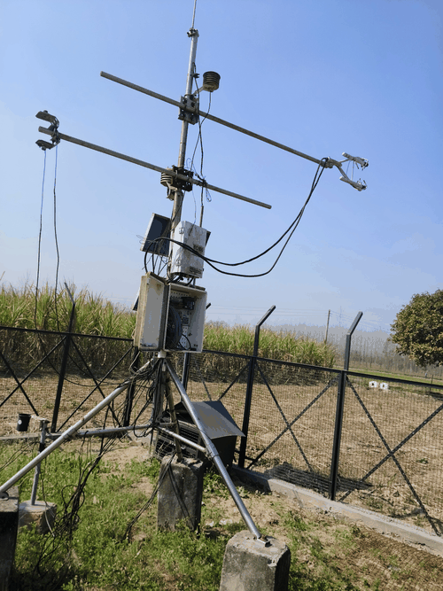
Eddy Covariance method (CO2)
| System | Open-path system |
|---|---|
| Wind speed | Integrated CO2/H2O Open-path gas analyzer with 3D Sonic Anemometer (IRGASON-EB-IC, Campbell Scientic) |
| Air temperature | Integrated CO2/H2O Open-path gas analyzer with 3D Sonic Anemometer (IRGASON-EB-IC, Campbell Scientic) |
| Water vapor | Integrated CO2/H2O Open-path gas analyzer with 3D Sonic Anemometer (IRGASON-EB-IC, Campbell Scientic) |
| CO2 | Integrated CO2/H2O Open-path gas analyzer with 3D Sonic Anemometer (IRGASON-EB-IC, Campbell Scientic) |
| Measurement height | 3.5 m |
| Sampling frequency | 10 Hz |
| Averaging time | 30 min |
| Data logger | CR-3000, Campbell, USA |
| Data storage | Compact Flash Card |
| Original data | Raw data |
Meteorology
| Observation items | Levels/Depth | Instrument |
|---|---|---|
| Global solar radiation (incoming) | 3.0 m above the surface | CNR4- 4 component Net radiometer (Kipp & Zonen, The Netherlands) |
| Global solar radiation (outgoing) | 3.0 m above the surface | CNR4- 4 component Net radiometer (Kipp & Zonen, The Netherlands) |
| Long-wave radiation (incoming) | 3.0 m above the surface | CNR4- 4 component Net radiometer (Kipp & Zonen, The Netherlands) |
| Long-wave radiation (outgoing) | 3.0 m above the surface | CNR4- 4 component Net radiometer (Kipp & Zonen, The Netherlands) |
| Net radiation | 3.0 m above the surface | CNR4- 4 component Net radiometer (Kipp & Zonen, The Netherlands) |
| PPFD (incoming) | 3.0 m above the surface | LI-190SL Qunatum Sensor (LICOR) |
| Air temperature | HC2S3- Rotronic Hygroclip2 Temperature/relative Humidity Probe | |
| Humidity | HC2S3- Rotronic Hygroclip2 Temperature/relative Humidity Probe | |
| Soil temperature | -5 cm, - 7.5 cm and -15 cm | CS650-Soil moisture and temperature sensor (Campbell Scientific) |
| Soil heat flux | -5 cm, - 7.5 cm and -15 cm | Heat flux plate (HFP01, Hukseflux The Netherlands ) |
| Soil water content | -5 cm, - 7.5 cm and -15 cm | CS650-Soil moisture and temperature sensor (Campbell Scientific) |
| Wind speed | 3.5 m above the surface | Integrated CO2/H2O Open-Path Gas analyzer with 3-D sonic anemometer (IRGASON-EB-IC, Campbell Scientific) |
| Wind direction | 3.5 m above the surface | Integrated CO2/H2O Open-Path Gas analyzer with 3-D sonic anemometer (IRGASON-EB-IC, Campbell Scientific) |
| Precipitation | 1 m above the surface | CS700-L: Tipping Bucket Rain Gauge |
| CO2 concentration | 3.5 m above the surface | Integrated CO2/H2O Open-Path Gas analyzer with 3-D sonic anemometer (IRGASON-EB-IC, Campbell Scientific) |
Observation Period and Data Availability
| Measurement Period | April 2014 – till date |
|---|---|
| Measurement Frequency | Continuous |
| Data Availability |
Contact
Dr. N.R. Patel
Email: nrpatel@iirs.gov.in; pnatoo@gmail.com
Project Investigator, Indian Institute of Remote Sensing ISRO, Govt. of India,
4, Kalidas Road, Dehradun- 248001, Uttarakhand, India.
Tel: +91-135-2524138
Shweta Pokhariyal
Email: shwetap@iirs.gov.in; shwetapokhariyal6@gmail.com
Research Scholar, Agriculture & Soils Department, Indian Institute of Remote Sensing ISRO, Govt. of India,
4, Kalidas Road, Dehradun- 248001 India.
Tel: +91-135-2524142
Dr. Abhishek Danodia
Email: abhidanodia@iirs.gov.in
Co-Project Investigator, Agriculture & Soils Department, Indian Institute of Remote Sensing ISRO, Govt. of India,
4, Kalidas Road, Dehradun- 248001 India.
Tel: +91-135-2524141
Technical Advisor
Dr. R. P. Singh
Email: rpsingh@iirs.gov.in
Director, Indian Institute of Remote Sensing ISRO,
Govt. of India, 4, Kalidas Road, Dehradun- 248001, Uttarakhand, India.
Tel: +91-135-2524101
Infrastructure
Eddy Covariance System Electric Power: Batteries (DC12V) +50 Watt Solar Power Facilities for communication, Security (Yes)
Research Fund
Indian Space Research Organization Climate & Atmospheric Programme (CAP) project
Publication
Patel, N. R., Pokhariyal, S., Chauhan, P., & Dadhwal, V. K. (2021). Dynamics of CO2 fluxes and controlling environmental factors in sugarcane (C4)–wheat (C3) ecosystem of dry sub-humid region in India. International Journal of Biometeorology, 65, 1069-1084. Pokhariyal, S., & Patel, N. (2021). Evaluation of variation in radiative and turbulent fluxes over winter wheat ecosystem along Indo-Gangetic region. Arabian Journal of Geosciences, 14, 1-11. Pokhariyal, S., Patel, N. R., Rana, R. S., & Chauhan, P. (2021). Environmental impact of lockdown amid COVID-19 over agricultural sites in Himalayan foothills. Journal of the Indian Society of Remote Sensing, 49, 1651-1659. Pokhariyal, S., & Patel, N. R. (2021). Comparison of empirical remote-sensing based models for the estimation of gross primary productivity using eddy covariance and satellite data over agroecosystem. Tropical Ecology, 62(4), 600-611. Patel, N., Pokhariyal, S., Kushwaha, S. P. S., Chauhan, P., & Dadhwal, V. K. (2023). Atmospheric CO2 concentration variability in response to contrasting vegetation ecosystems in Himalayan foothills. Arabian Journal of Geosciences, 16(3), 184.