
PDF: Palangkaraya drained forest
General site details
| Site name | Palangkaraya drained forest |
|---|---|
| AsiaFlux site code | |
| Location | Kalangpangan, Palangkaraya, Central Kalimantan, Indonesia |
| Position | 2º 20' 42" S, 114º 2' 11" E |
| Elevation | 30 m above sea level |
| Slope | 0 deg |
| Terrain type | Flat |
| Area | Greater than 50 km2 |
| Fetch | About 400, 500, 1500 m, and longer than 5000 m, respectively, for the north, east, west and south directions |
| Climate | Tropics (Dry season: May or June through October or November) |
| Mean annual air temperature | 26.3 degC (2002-2005) |
| Mean annual precipitation | 2231 mm (2002-2005) |
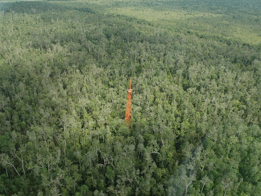
| Vegetation type | Tropical peat swamp forest (evergreen) drained in the 1990’s |
| Dominant Species (Overstory) | Combretocarpus rotundatus, Cratoxylum arborescens, Buchanania sessifolia and Tetramerista glabra |
| Dominant Species (Understory) | - |
| Canopy height | About 26 m |
| Age | - |
| LAI | Around 5 m2 m-2 in plant area index (PAI) at 1.3 m height measured in June 2006 using a plant canopy analyzer (LAI2000, Licor) |
| Soil type | Peat (drained by canal built in the late 1990s; Hirano et al., Carbon dioxide balance of a tropical peat swamp forest in Kalimantan, Indonesia. Global Change Biology, 13, 412-425, 2007) |
Observation
Eddy Covariance method (CO2)
| System | Open-path system |
|---|---|
| Wind speed | CSAT3, Campbell, USA |
| Air temperature | CSAT3, Campbell, USA |
| Water vapor | Open-path (LI-7500, LI-COR, USA) |
| CO2 | Open-path (LI-7500, LI-COR, USA) |
| Measurement height | 41.3 m |
| Sampling frequency | 10 Hz |
| Averaging time | 1 hour |
| Data logger | 8421, Hioki E. E. Corp., Ueda, Japan |
| Data storage | CF |
| Original data | Raw data |
Meteorology
| Observation items | Levels/Depth | Instrument |
|---|---|---|
| Global solar radiation(incoming) | 40.6 m | CNR1, Kipp & Zonen, The Netherlands |
| Global solar radiation (outgoing) | 40.6 m | CNR1, Kipp & Zonen, The Netherlands |
| Long-wave radiation(incoming) | 40.6 m | CNR1, Kipp & Zonen, The Netherlands |
| Long-wave radiation(outgoing | 40.6 m | CNR1, Kipp & Zonen, The Netherlands |
| Net radiation | 40.6 m | CNR1, Kipp & Zonen, The Netherlands |
| PPFD (incoming) | 40.6 m | LI-190S, Licor, USA |
| PPFD (outgoing) | 40.6 m | LI-190S, Licor, USA |
| Direct / diffuse radiation | - | |
| Direct / diffuse PPFD | - | |
| Air temperature | 41.7 m | HMP45, Vaisala with nonventilated radiation shield (DTR403A, Vaisala, Finland) |
| Humidity | 41.7 m | HMP45, Vaisala with nonventilated radiation shield (DTR403A, Vaisala, Finland) |
| Soil temperature | 0.05 m | Thermocouple thermometer |
| Soil heat flux | - | |
| Soil water content | 0-0.2 m | CS615, Campbell |
| Wind speed | 41.7 m | 03001-5, R.M. Young |
| Wind direction | 41.7 m | 03001-5, R.M. Young |
| Barometric pressure | - | |
| Precipitation | 41 m | TE525, Campbell, USA) |
| CO2 concentration | 2, 10, 18, 25, 30 and 41.3 m | LI800 or LI820, Licor, USA |
Other
| Soil respiration | Continuous from January 2004 through April 2006 |
| Photosynthesis | - |
| Ecological investigation | - |
Other Information
| The site is operated in collaboration with University of Palangkaraya (UNPAR), Indonesia. |
Observation Period and Data Availability
| Measurement Period | November 2001 to present |
|---|---|
| Measurement Frequency | Continuous |
| Data Availability | 2002-2005 in AsiaFlux Database |
Contact
Takashi Hirano (hirano [at] env.agr.hokudai.ac.jp) Graduate School of Agriculture,Hokkaido UniversityKita-ku, Sapporo 060-8589, Japan TEL +81-11-706-3689FAX +81-11-727-3689
Infrastructure
Tower,Solar energy system
Research Fund
Core University Program (FY1997-2006) from JSPS, Japan Grant-in- Aid for Scientific Research (Nos.13375011, 15255001 and 18403001) from the Japanese Ministry of Education, Culture, Sports, Science and Technology, Japan (FY2001-2008)
Calibration Information
CO2 analyzers were calibrated every three months using span gases.
Publication
Hirano et al., Carbon dioxide balance of a tropical peat swamp forest in Kalimantan, Indonesia. Global Change Biology, 13, 412-425, 2007 Hirano et al., Energy balance of a tropical peat swamp forest in Central Kalimantan, Indonesia. Phyton, 45, 67-71, 2005.