
ITP: Intact Tropical Peatland
General site details
| Site name | Intact Tropical Peatland |
|---|---|
| AsiaFlux site code | ITP |
| Location | Kampar Peninsula, Riau, Indonesia |
| Position | 0° 23'42.735" N, 102° 45'52.382" E (World geodetic system 1984) |
| Elevation | 9 m above mean sea level |
| Slope | 0.025° in 2 km radius of the tower location from south to the north side |
| Terrain type | Flat |
| Area | > 15 km2 |
| Fetch | Minimum 3 km |
| Climate | Tropical rain forest (Tropical-Fully humid (Af)) |
| Mean annual air temperature | 26.8 ± 0.9℃ (June 2017 to May 2020) |
| Mean annual precipitation | 1757 mm (June 2017 to May 2020) |
| Vegetation type | Tropical peat swamp forest |
| Dominant Species (Overstory) | Shorea uliginosa, Calophyllum ferrugineum, and Syzygium spp |
| Dominant Species (Understory) | Pandanus spp., Cyrtostachys renda, and Nepenthes spp |
| Canopy height | 32 ± 6 m |
| Age | - |
| LAI | - |
| Soil type | Peat soil; contains ~99% organic material with carbon content of ~55% |
Observation
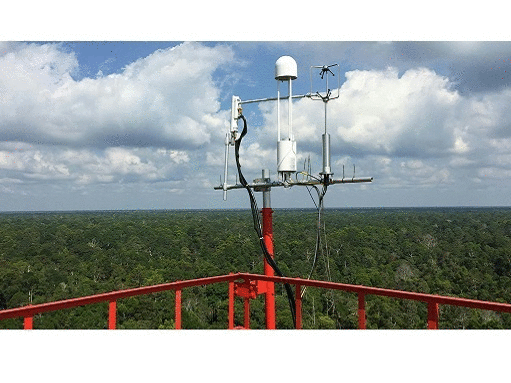
Eddy Covariance method (CO2)
| System | Enclosed path CO2/H2O Analyzer (LI-7200, LI-COR Inc. USA) |
|---|---|
| Wind speed | Windmaster Pro Anemometer, 3-Axis Ultrasonic Anemometer (7900-415-50, Gill instruments Ltd, UK) |
| Air temperature | Windmaster Pro Anemometer, 3-Axis Ultrasonic Anemometer (7900-415-50, Gill instruments Ltd, UK) |
| Water vapor | Enclosed path CO2/H2O Analyzer (LI-7200, LI-COR Inc. USA) |
| CO2 | Enclosed path CO2/H2O Analyzer (LI-7200, LI-COR Inc. USA) |
| Measurement height | 51.6 m |
| Sampling frequency | 10 Hz |
| Averaging time | 30 minutes |
| Data logger | Analyzer Interface Unit (AIU) (LI-7550, LI-COR Inc. USA) |
| Data storage | Removable flash disk (APRO, Industrial Grade USB Flash Disk) |
| Original data | Raw data on 10Hz frequency data compilation |
Meteorology
| Observation items | Levels/Depth | Instrument |
|---|---|---|
| Short-wave radiation (incoming) | 49 m | CNR4 net radiometer (150471, Kipp & Zonen Inc. Netherlands) |
| Short-wave radiation (outgoing) | 49 m | CNR4 net radiometer (150471, Kipp & Zonen Inc. Netherlands) |
| Long-wave radiation (incoming) | 49 m | CNR4 net radiometer (150471, Kipp & Zonen Inc. Netherlands) |
| Long-wave radiation (outgoing) | 49 m | CNR4 net radiometer (150471, Kipp & Zonen Inc. Netherlands) |
| Net radiation (balance of short-wave and long-wave radiation) | 49 m | CNR4 net radiometer (150471, Kipp & Zonen Inc. Netherlands) |
| Photosynthetic photon flux density | 49 m | Quantum sensors (LI-190SL-50, LI-COR Inc. USA) |
| Direct/diffuse radiation | - | - |
| Direct/diffuse PPFD | - | - |
| Air temperature | 4,11,20,29,48 m | Humidity & Temperature probe (HMP155, Vaisala Inc. Finland) |
| Humidity | 4,11,20,29,48 m | Humidity & Temperature probe (HMP155, Vaisala Inc. Finland) |
| Soil temperature | -0.15 & -1.5 m | Stevens Hydra ProbeⅡ, Stevens Water Monitoring Systems, Inc.) and Solinst Levelogger 529 Model 3001 |
| Soil heat flux | -0.15 m | Self-calibrating heat flux sensor (HFP01SC, Hukseflux) |
| Soil water content | -0.15 m | Stevens Hydra ProbeⅡ, Stevens Water Monitoring Systems, Inc.) |
| Wind speed | 51.6 m | Windmaster Pro Anemometer, 3-Axis Ultrasonic Anemometer(7900-415-50, Gill instruments Ltd, UK) |
| Wind direction | 51.6 m | Windmaster Pro Anemometer, 3-Axis Ultrasonic Anemometer(7900-415-50, Gill instruments Ltd, UK) |
| Atmospheric pressure | 51.6 m | Enclosed path CO2/H2O Analyzer (LI-7200, LI-COR Inc. USA) |
| Precipitation | 1.5 m | Manual rain gauge bucket (NETA, 250 mm, 10 inch) |
| CO2 concentration | 4,11,29,48 m | Closed path CO2 Analyzer (LI-8100, LI-COR Inc. USA) |
Fluxes of non-CO2 gases
| Gas | CH4, N2O |
| Method | CH4 (Open Path CH4 analyzer LI-7700 LI-COR Inc. USA), N2O (Manual ground chamber based, analyzed using gas chromatograph-SRI ®8610C, USA) |
| Measurement height | CH4 (51.6m), N2O (measurements at peat surface) |
| Data logger | CH4 (LI-7550 Analyzer Interface Unit (AIU) LI-COR Inc. USA) |
| Data storage | Removable flash disk (APRO, Industrial Grade USB Flash Disk) |
| Chamber size of N2O | Volume: 6.750cm3, Chamber Dimensions: 30cm L x 15cm W x 15cm H |
Other
| Soil respiration | - |
| Photosynthesis | No |
| Ecological Investigation | Tree diameter at breast height, tree stand density, micro-topography, litter fall inputs, Bulk density, N, P, K and C concentrations |
| Peat subsidence | Manual subsidence poles using perforated 5cm diameter hollow PVC pipes, inserted vertically into the peat and anchored into underlying mineral subsoil, measurements frequency: Quarterly |
| Ground water level | Automated groundwater level logger (Solinst Levelogger Model 3001), placed inside a perforated polyvinyl chloride (PVC) pipe, measurements frequency: 30 min. |
Observation Period and Data Availability
| Measurement Period | June 2017 to present |
|---|---|
| Measurement Frequency | Continuous (10 Hz (30 minutes averaged) |
| Data Availability | N/A |
Contact
Chandra Shekhar Deshmukh (Chandra_Deshmukh[at]aprilasia.com) Asia Pacific Resources International Limited (APRIL), JI. Lintas Timur, Pangkalan Kerinci, Kabupaten Pelalawan Riau 28300, Indonesia
Infrastructure
Tower, Solar cell electrical power (DC), Accommodation (Solar battery house and Guest gazebo), Telecommunication signal available
Research Fund
Asia Pacific Resources International Limited (APRIL) https://www.aprilasia.com/en/
Calibration Information
Both enclosed-path (LI-7200) and closed-path (LI-8100) CO2 analyzers were calibrated every three months using ultra high-purity nitrogen as the zero-point gas for CO2 and reference gases with concentration of 396ppm CO2 in air (certified grade ±1ppm)
Publication
Deshmukh, C. S., Julius, D., Evans, C. D., Nardi, Susanto, A. P., Page, S. E., Gauci, V., Lauren, A., Sabiham, S., Agus, F., Asyhari, A., Kurnianto, S., Suardiwerianto, Y., & Desai, A. R. (2019). Impact of forest plantation on methane emissions from tropical peatland. Global Change Biology, 24(9), https://onlinelibrary.wiley.com/doi/10.1111/gcb.15019 Deshmukh, C. S., Julius, D., Desai, A. R., Asyhari, A., Page, S. E., Nardi, Susanto, A. P., Nurholis, Hendrizai, M., Kurnianto, S., Suardiwerianto, Y., Salam, Y. W., Agus, F., Astiani, D., Sabiham, S., Gauci, V. & Evans, C. D. (2021). Conservation slows down emission increase from a tropical peatland in Indonesia. Nature Geoscience,https://rdcu.be/cnL8u or https://www.nature.com/articles/s41561-021-00785-2